Rothera Station Hazards and Instruments
- Collections
- Edition
- 4
- Published
- Access
- Restricted
Produced by the Mapping and Geographic Information Centre, British Antarctic Survey, 2025, version 4, https://data.bas.ac.uk/maps/2001.
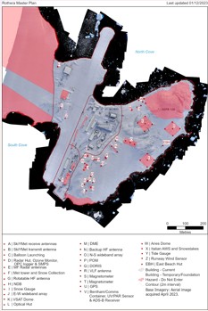
Site map of Rothera Research Station, showing locations of hazards, instruments, buildings, and access and exclusion zones. Projection: WGS84 Lambert Conformal Conic, central meridian 68° 7' 20"" W. Standard parallels at 63° 20' S and 76° 40' S.
This is a licence summary, see the Formal Licence External link, opens in a new window. for more information.
Bounding Coordinates
- South-West Corner (min x/y)
- South: -67.572222, West: -68.13333
- North-East Corner (max x/y)
- North: -67.563889, East: -68.111111
Temporal Range
- Start
- End
- -
Lineage Statement
Map produced in ArcGIS Pro v3.3. Data sources:
- Operations data: sourced from BAS Operations, 2024
- Coastline and rock outcrop: SCAR Antarctic Digital Database, 2024
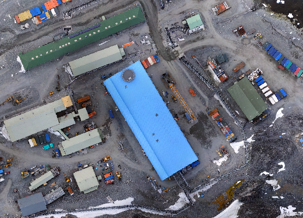
- Imagery: British Antarctic Survey aerial photography, March 2023
- Contours: Derived from DEM produced from British Antarctic Survey aerial photography, February 2019
- Place names: selected from the British Antarctic Territory gazetteer, accessed August 2024
Related to
Map of Rothera Research Station, showing locations of instruments and and buildings as of December 2023. Projection: Rothera Local Grid.
Part of these collections
A collection of maps produced for BAS Operations activities by the Mapping and Geographic Information Centre, British Antarctic Survey.
A collection of maps produced for BAS Polar Estates activities.
Item Information
- Item ID
- 1680a763-02b0-4718-802c-bf6f89744f4e
- Item Type
- PRODUCT (MAP)
- Series
- BAS Site Maps
- Scale
- 1:2,000
- Page Size
- 662 x 702 mm (width x height)
- Aliases
- Item edition
- 4
- Item Created
- Item Published
- Item Released
- Item Status
- Item is complete and recommended for general use
- Item Update Frequency
- Item may be updated if needed
Metadata Information
- Last updated
- Metadata Standard
- ISO 19115-2 Geographic Information - Metadata - Part 2: Extensions for Imagery and Gridded Data
- Metadata Standard Version
- ISO 19115-2:2009(E)
- Metadata Profiles
- British Antarctic Survey (BAS) Mapping and Geographic Information Centre (MAGIC) Discovery Metadata Profile (v2) External link, opens in a new window.
- British Antarctic Survey (BAS) Mapping and Geographic Information Centre (MAGIC) Administration Metadata Profile (v1) External link, opens in a new window.
- Metadata Licence
- Creative Commons Attribution-NoDerivatives 4.0 International External link, opens in a new window.
- Metadata Links
- Item page build time
Alternative contact methods
By post
British Antarctic SurveyHigh Cross
Madingley Road
Cambridge
Cambridgeshire
CB3 0ET
United Kingdom
By phone
By email
Privacy Notice
If you contact us, your personal information will be retained for up to three years and then deleted. It will only be used to contact you regarding your enquiry. If this item relates to an external organisation, we may share an anonymised version of your enquiry with them to help answer your query.
We use Cloudflare Turnstile, a third-party service, to protect against spam enquires.
See our privacy policy for more information.