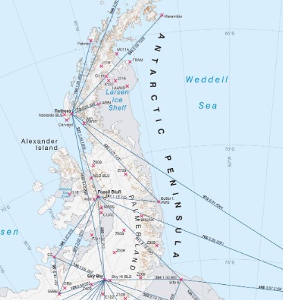
Rothera Operations Map
- Collections
- Edition
- 1
- Published
- Access
- Restricted
Produced by the Mapping and Geographic Information Centre, British Antarctic Survey, 2025, version 1, https://data.bas.ac.uk/maps/2021.
Topographic Map of the Ryder Bay region, including Rothera Research Station. Includes satellite imagery, contours, spot heights, and operational data. Projection: WGS84 Lambert Conformal Conic, standard parallels at 67°33’S and 67°35’S, central meridian at 68°07’W
This is a licence summary, see the Formal Licence External link, opens in a new window. for more information.
Bounding Coordinates
- South-West Corner (min x/y)
- South: -67.6755987, West: -68.4557808
- North-East Corner (max x/y)
- North: -67.4810503, East: -67.9801936
Temporal Range
- Start
- End
- -
Lineage Statement
Map produced in ArcGIS Pro v3.1. Data sources:
- Operations data : sourced from BAS Operations, 2024.
- Coastline: SCAR Antarctic Digital Database, 2024
- Contours: derived from REMA v1 (Howat et al, 2019), adjusted for EGM08 geoid.
- Spot Heights and survey points BAS Geodetic Survey Network and UK Antarctic Place-names Committee Gazetteer (accessed 2024)
- Imagery: Copernicus Sentinel-2a imagery, acquired 2024-10-07
Bathymetry: Fremand, A. (2020). Gridded bathymetric compilation of Ryder Bay from raw and processed multibeam echosounder data collected by the RRS James Clark Ross (2001 - 2016) [Data set]. UK Polar Data Centre, Natural Environment Research Council, UK Research & Innovation. https://doi.org/10.5285/0F4D7D85-1E38-4E0E-80AF-1FCD85267FFC Anderson, John. Processed Multibeam Sonar Data (version 2) near the Antarctic Peninsula acquired during Nathaniel B. Palmer expedition NBP0201 (2002). Marine Geoscience Data System (MGDS) https://doi.org/10.1594/IEDA/100290 Jacobs, Stan. Processed Multibeam Sonar Data (version 2) from the Amundsen Sea acquired during Nathaniel B. Palmer expedition NBP0901 (2009). Marine Geoscience Data System (MGDS) https://doi.org/10.1594/IEDA/100388
Domack, Eugene. Processed Multibeam Sonar Data (version 1) near the Antarctic Peninsula acquired during Nathaniel B. Palmer expedition NBP1001 (2010). Marine Geoscience Data System (MGDS) https://doi.org/10.1594/IEDA/100394 Rynearson, Tatiana. Raw Acoustic Backscatter and Swath Bathymetry Data from the Southern Ocean acquired during R/V Nathaniel B. Palmer expedition NBP1701 (2016). Marine Geoscience Data System (MGDS) https://doi.org/10.1594/IEDA/324281 Kate Retallick, Floyd Howard (2019) Raw bathymetry data of Ryder Bay acquired during RRS James Clark Ross expedition JR18003 (2018). Data under embargo. Shoal areas: Compiled from UK Hydrographic Office Admiralty Chart No. 3462 (1999) and BAS Scistamap Sheet 1B (1995).
Offshore rocks: Admiralty Chart, BAS Scistamap Sheet 1B and interpreted from BAS/5/05 aerial photographs. WARNING: The UK Hydrographic office has not verified the information within this product for navigation purposes and does not accept liability for accuracy of reproduction or any modification made thereafter. NOT TO BE USED FOR NAVIGATIONPlace names: selected from the British Antarctic Territory gazetteer, accessed 2024
Part of these collections
A collection of maps produced for BAS Operations activities by the Mapping and Geographic Information Centre, British Antarctic Survey.
Item Information
- Item ID
- 1fc27819-e4ec-4b77-bac3-8557c8cef943
- Item Type
- PRODUCT (MAP)
- Series
- BAS Local Travel Maps
- Scale
- 1:25,000
- Page Size
- 918 x 864 mm (width x height)
- Aliases
- Item edition
- 1
- Item Created
- Item Published
- Item Released
- Item Status
- Item is complete and recommended for general use
- Item Update Frequency
- Item may be updated if needed
Metadata Information
- Last updated
- Metadata Standard
- ISO 19115-2 Geographic Information - Metadata - Part 2: Extensions for Imagery and Gridded Data
- Metadata Standard Version
- ISO 19115-2:2009(E)
- Metadata Profiles
- British Antarctic Survey (BAS) Mapping and Geographic Information Centre (MAGIC) Discovery Metadata Profile (v2) External link, opens in a new window.
- British Antarctic Survey (BAS) Mapping and Geographic Information Centre (MAGIC) Administration Metadata Profile (v1) External link, opens in a new window.
- Metadata Licence
- Creative Commons Attribution-NoDerivatives 4.0 International External link, opens in a new window.
- Metadata Links
- Item page build time
Alternative contact methods
By post
British Antarctic SurveyHigh Cross
Madingley Road
Cambridge
Cambridgeshire
CB3 0ET
United Kingdom
By phone
By email
Privacy Notice
If you contact us, your personal information will be retained for up to three years and then deleted. It will only be used to contact you regarding your enquiry. If this item relates to an external organisation, we may share an anonymised version of your enquiry with them to help answer your query.
We use Cloudflare Turnstile, a third-party service, to protect against spam enquires.
See our privacy policy for more information.