Air Operations Depot Map
- Collections
- Edition
- 7
- Published
- Access
- Restricted
Produced by the Mapping and Geographic Information Centre, British Antarctic Survey, 2025, version 7, https://data.bas.ac.uk/maps/2037.
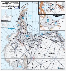
Map of Antarctica showing locations of depots used for BAS Air Unit operations planning. Projection: WGS84 Antarctic Polar Stereographic.
This is a licence summary, see the Formal Licence External link, opens in a new window. for more information.
Bounding Coordinates
- South-West Corner (min x/y)
- South: -90.0, West: -160.0
- North-East Corner (max x/y)
- North: -60.0, East: 0.0
Temporal Range
- Start
- End
Lineage Statement
- Operations data: BAS Operations, 2025. COMNAP Antarctic Facilities List, 2024.
- Coastline and rock outcrop: SCAR Antarctic Digital Database, 2024.
- Contours: derived from Polar Geospatial Center REMA v2 100m mosaic. Where there were holes in this dataset, these have been filled with Copernicus GLO-90 Digital Elevation Model, downsampled to 100m. This dataset was smoothed for the purposes of this map.
- Place names - British Antarctic Territory Gazetteer and the SCAR Composite Gazetteer of Antarctica. Datasets accessed August 2025.
Part of these collections
A collection of maps produced for BAS Air Unit activities by the Mapping and Geographic Information Centre, British Antarctic Survey.
Item Information
- Item ID
- c74b4a81-26e3-4c71-80f6-9a73c2c68489
- Item Type
- PRODUCT (MAP)
- Series
- BAS Air Operations Maps
- Scale
- 1:1,000,000
- Page Size
- 760 x 810 mm (width x height)
- Aliases
- Item edition
- 7
- Item Created
- Item Published
- Item Released
- Item Status
- Item is complete and recommended for general use
- Item Update Frequency
- Item may be updated if needed
Metadata Information
- Last updated
- Metadata Standard
- ISO 19115-2 Geographic Information - Metadata - Part 2: Extensions for Imagery and Gridded Data
- Metadata Standard Version
- ISO 19115-2:2009(E)
- Metadata Profiles
- British Antarctic Survey (BAS) Mapping and Geographic Information Centre (MAGIC) Discovery Metadata Profile (v2) External link, opens in a new window.
- British Antarctic Survey (BAS) Mapping and Geographic Information Centre (MAGIC) Administration Metadata Profile (v1) External link, opens in a new window.
- Metadata Licence
- Creative Commons Attribution-NoDerivatives 4.0 International External link, opens in a new window.
- Metadata Links
- Item page build time
Alternative contact methods
By post
British Antarctic SurveyHigh Cross
Madingley Road
Cambridge
Cambridgeshire
CB3 0ET
United Kingdom
By phone
By email
Privacy Notice
If you contact us, your personal information will be retained for up to three years and then deleted. It will only be used to contact you regarding your enquiry. If this item relates to an external organisation, we may share an anonymised version of your enquiry with them to help answer your query.
We use Cloudflare Turnstile, a third-party service, to protect against spam enquires.
See our privacy policy for more information.